History
The recorded title history of the land held by Mountain View Shores Association members, compiled by Tom Gore from deeds and plans at the York County Registry of Deeds.
About this history
Tom Gore compiled this history from deeds, depositions and subdivision plans recorded at the York County Registry of Deeds in Alfred, Maine. It covers the land shown on the Mountain View Shores and Woodland Shores subdivision plans, from the first English claims to the transfer of the common land to the association in 1983. It does not cover sales of individual lots.
Book and page numbers refer to the York County Registry of Deeds, which can be searched online at the York County Registry of Deeds.
Spelling in the old records varies, especially for names given by indigenous people. Capt. Sandy also appears as Capt. Sunda and as Sumbee. Several waterways have changed names: Great East Lake was Salmon Falls Pond, Little Ossipee Pond is now Balch Lake, and the Salmon Falls River was the Newichewannack River.
Colonial claims and the Ossipee Tract
The land was occupied and held in common by the Wabanaki Confederation, and more specifically by the Ossipee (Newichewannack) tribe.
- 1622
- The Council for New England grants the lands between the Merrimac and Kennebec Rivers to Capt. John Mason and Sir Ferdinando Gorges, without bounds to the north and west.
- 1643
- Mr. Roles, a Sagamore, conveys land between Little Johns Falls, at the outlet of Salmon Pond, and the Little Ossipee River to Humphry Chadbourne. Book 1, page 4.
- 1657
- Sitterygussit, a Sagamore, conveys a tract to Francis Small, who deeds a half interest to John Phillips. Book 1, page 83.
- 1668
- Capt. Sandy, a Sagamore of the Ossipee, deeds the Ossipee Tract, about 20 miles square, to Francis Small. Book 42, page 239. Small conveys a half interest to Nicholas Shapleigh. Book 43, page 21.
- 1773
- The lost deeds, found in 1770, are recorded. The Shapleigh heirs have the tract surveyed and divided. Depositions at Book 43, pages 22 and 63.
- 1782
- The Massachusetts General Court confirms the tract, then called Hubbardstown, to the heirs of Nicholas Shapleigh, the proprietors. Acts of 1782, Chapter 27.
- 1785
- Hubbardstown is incorporated as the Town of Shapleigh.
- 1795
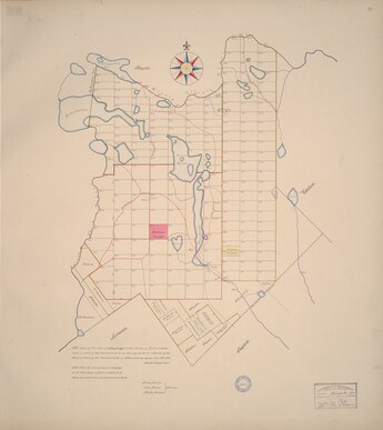
- The proprietors' map of Shapleigh shows its divisions, ranges and lots, before dams changed the shape of Horn Pond.
- 1830
- The west parish of Shapleigh separates and incorporates as the Town of Acton.
Farm land, 1779 to 1928
The association land lies in lots 11, 12 and 13 of the tenth range, second division, of the proprietors' plan.
- 1779
- Jonathan Palmer of Wakefield buys lots 11, 12 and 13 in the tenth range, about 150 acres each. Book 46, pages 46, 75 and 76A.
- 1804
- Palmer conveys the southwest half of lot 11 to Joseph Wiggin. Book 109, page 27A.
- 1809
- Joseph Wiggin conveys the southwest half of lot 11 to Nathaniel Ricker. Book 109, page 28.
- 1824
- James Jones and Samuel Runnels convey about 35 acres of lot 12, bounded by the Salmon Falls River, to Nathaniel Ricker. Book 117, page 241.
- 1836
- The land in lots 11 and 12 passes within the Ricker family. Book 156, page 85, and Book 158, page 232.
- 1838
- Nathaniel Ricker drowns in Horn Pond with a team of horses in February.
- 1840
- The Ricker family conveys the land to Daniel Ricker. Book 168, page 276.
- 1848
- Daniel Ricker conveys riparian rights to the Great Falls Manufacturing Company: the right to maintain dams in the Salmon Falls River watershed and to flood his land to the height of the dams. Book 209, pages 167 and 168.
- 1862
- Daniel Ricker grants the Great Falls Manufacturing Company the right to build a canal at the outlet of East Pond.
- 1870
- After Daniel Ricker's death the land passes to his son, Joel B. Ricker. Book 317, page 266, and Book 325, page 96.
- 1903
- On Joel B. Ricker's death the probate court awards the Acton lands and buildings to Daniel Webster Ricker. Book 529, page 294.
- 1928
- Daniel Webster Ricker's sons convey their interest to his daughter, Marion R. Sargent. Book 787, page 552.
Camp Sa-Gis-Ca, 1939 to 1971
- 1939
- Marion and Herbert Sargent convey the property to H. Danforth Ross. Book 932, page 456.
- 1940
- H. Danforth Ross conveys the property to Sanford Girl Scouts, Inc., and it operates as Camp Sa-Gis-Ca. Book 915, page 504.
- 1955
- Sanford Girl Scouts, Inc. conveys the camp to Gorgeana Girl Scout Council Inc. Book 1567, page 257.
- 1963
- Gorgeana Girl Scout Council consolidates with Kennebec Girl Scout Council, which takes the whole camp property. Book 1825, page 840.
The subdivisions and the association
- 1971
- Kennebec Girl Scout Council conveys the camp property to Norland Development. This deed covers all the land now owned by association members, individually and in common. Book 1926, page 290.
- 1971
- Norland Development Corp.'s Mountain View Shores subdivision plan is recorded on 28 October. Plan Book 53, page 37.
- 1972
- Nor-Land Development conveys the land to Lakeside Investment Corp. Book 1953, page 860.
- 1973
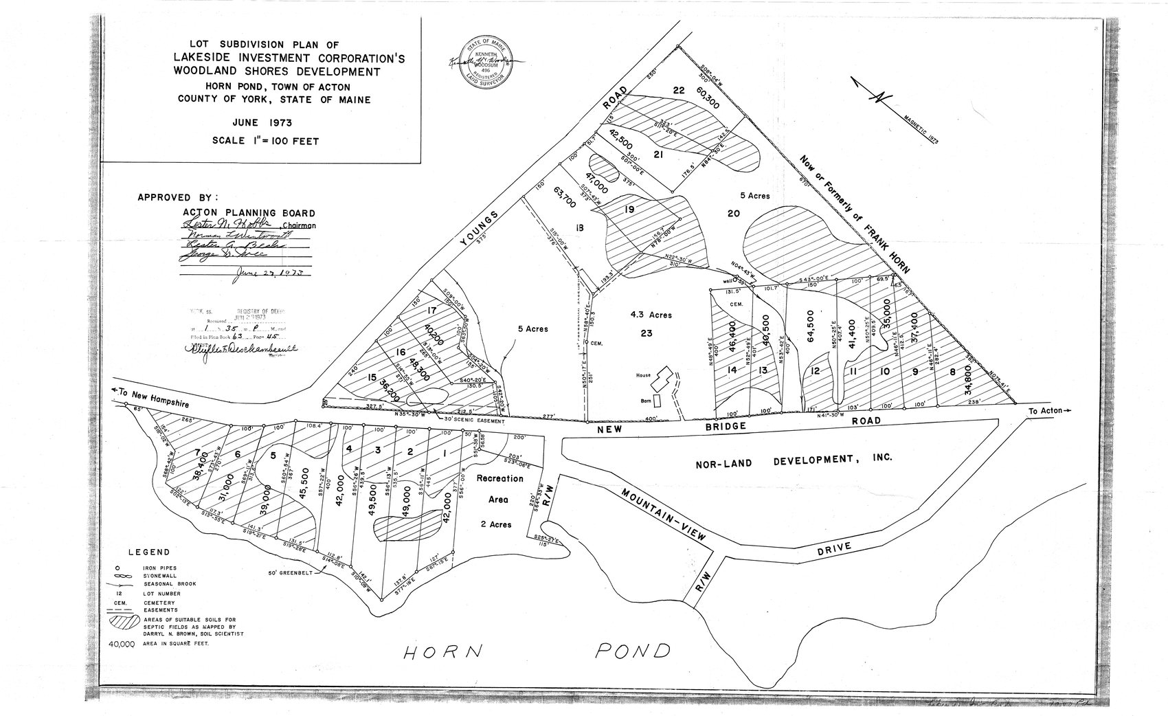
- Lakeside Investment Corporation's Woodland Shores Development plan is recorded on 29 June. Plan Book 63, page 45.
- 1983
- Lakeside Investment Corp. conveys all the land held in common within the two subdivisions to Mountain View Shores Assn., Inc. Book 3141, page 4.
Source
Tom Gore, Title History of Mountain View Shores Assn. Member's Properties, with preface, draft of 26 December 2025. Download the full title history (PDF, 1.9 MB), including copies of the original deeds.